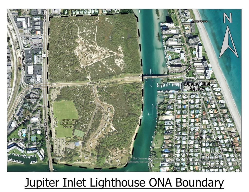
Jupiter Inlet Lighthouse, situated inside the Jupiter Inlet Lighthouse Outstanding Natural Area (ONA), is located in Palm Beach County on Florida’s Atlantic coast. The city of Jupiter is the northernmost community in the Miami Metropolitan Area. The light was constructed roughly 1500 yards north of the natural Jupiter Inlet, which silted over before construction of the light began. Currently, the lighthouse sits at the confluence of the Indian and Loxahatchee Rivers, directly adjacent to the man-made inlet which was constructed in 1922. This area is the eastern most point in Florida, where the coast juts out towards the Gulf Stream before retracting back to the west as it rounds Miami and reaches into Florida Bay. Because of its location, this point has a long history of European contact with native tribes as ships were wrecked in the treacherous waters between the Gulf Stream and what is today referred to as Florida’s Treasure Coast. This area has also traditionally been highly susceptible to storm erosion and dune drift that, at times, closed the natural inlet in Jupiter.
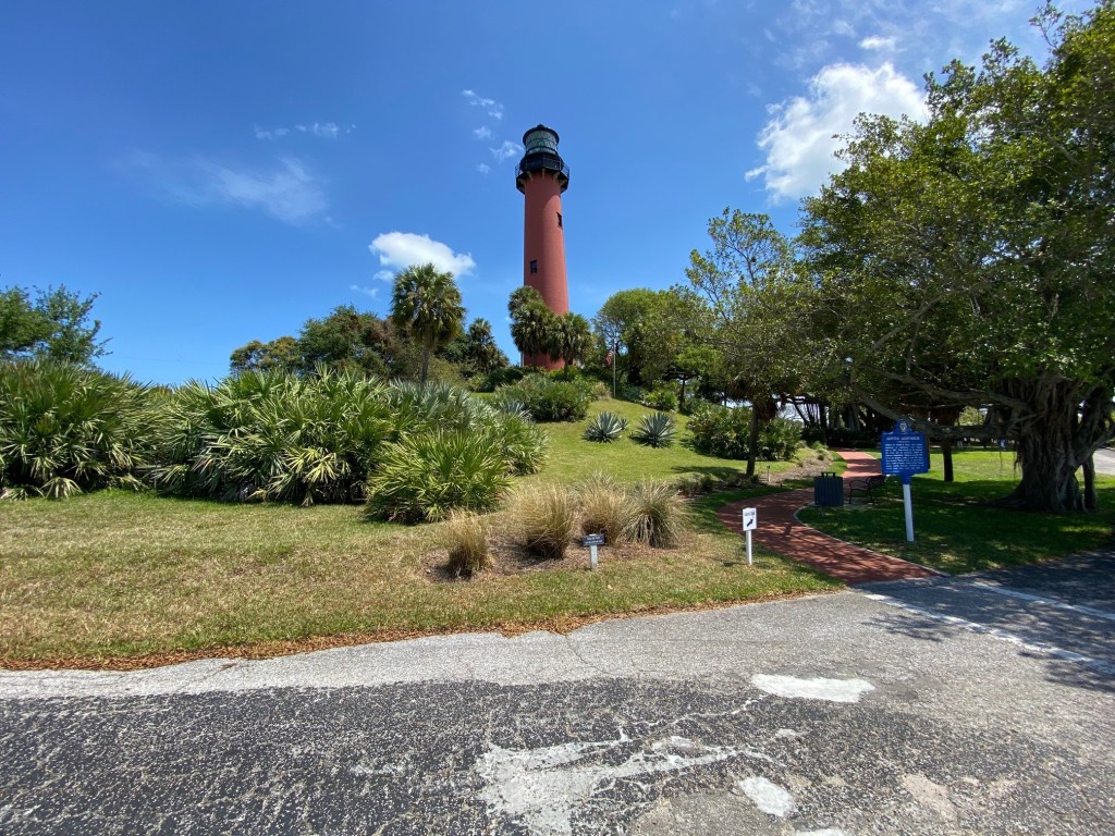
The red brick lighthouse at Jupiter Inlet was constructed between 1859-1860 and was first lit in July 1860, but habitation at the site goes back thousands of years. The oldest evidence of human habitation in the area around Jupiter Inlet Lighthouse is perhaps five thousand years old, but it seems the majority of habitation has occurred in the last two thousand years.
In 1861 the lighthouse was disabled The lighthouse was relit in 1866 and is still operational today. Since its construction, the lighthouse has also served as a weather station, signal station, and radio station for various branches of the armed services. In 1939 operation of all lighthouses was transferred to the U.S. Coast Guard and a secret radio and code breaking installation known as Station J was established and operated against German U-Boats in the Atlantic
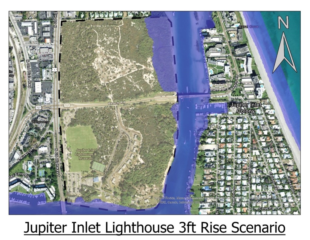
Over the next several decades Jupiter Inlet and the surrounding areas can expect to experience about a foot of sea level rise. This amount of sea level rise will not threaten the site with inundation, with the possible exception of some shoreline areas in the northern portion of the ONA. This will, however, increase the risk of climate-related problems the area already suffers from. With increased hightides, storm surge from offshore storms increases the risk that outer dunes may be overtopped, pushing water into the Intercoastal Waterway and possibly temporarily inundating interior areas such as the Jupiter ONA. While permanent damage to the site is unlikely in this situation, standing water on the site can disrupt operations and diminish the direct economic impact that the site can contribute to the community. Based on sea level rise modeling, the northeast corner of the Jupiter ONA is the most susceptible to inundation and by mid-century will almost certainly begin to experience inundation problems on a permanent or semi-permanent basis. Under a 6-foot rise scenario, the eastern shoreline of the ONA could retreat by as much as 500 feet along a portion of the shoreline that is roughly equivalent to three quarters of the length of the ONA and museum grounds. Under this same scenario, the area on the southern shore of the property is also threatened by inundation, particularly around the museum and administrative offices.